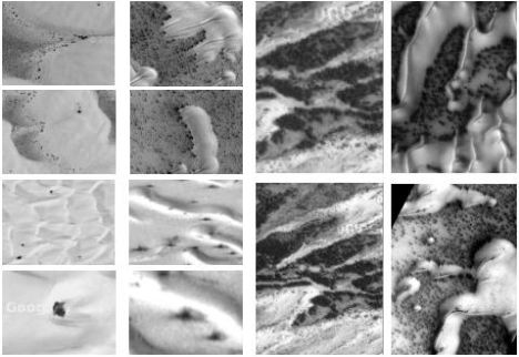
Trees on Mars?
Row 1 and 3: Satellite images (from Google) of trees and
shrubs around dunes in White Sands National Monument, New Mexico.
Row 2
and 4: Mars Global Surveyor images of similar spots around dunes in the
northern polar regions of Mars, an area of high concentration of frozen
water.
The northern polar regions of Mars has been
found, by instruments onboard both NASA and ESA spacecraft, to have high
concentrations of frozen water in the upper layers of soil, over 50% above
latitude 60N. In this water rich zone, the Mars Global Surveyor (MGS)
high-resolution camera has also captured many images of spots around dunes that
bear a striking similarity to vegetation around dunes in the White Sands
National Monument in New Mexico. Could this be life on Mars?
Satellite
images can be tricky to interpret. Do a Google search for “Face on Mars” and
you’ll get 56,900 results concerning the “face” that amateurs thought martians
had carved from a mountain. So, although these MGS images from Mars look similar
to satellite images of desert vegetation on Earth, an expert at satellite
imagery analysis might be able to offer another explanation.
The best
specialists for this type of analysis are not at NASA. NASA planetary scientists
are great at identiying craters, dunes and other geographical features, but
until the Mars Global Surveyor they had little experience interpreting
high-resolution images of planetary surfaces. On the other hand, the scientists
at the U.S.Geological Survey (USGS) National
Center for Earth Resources Observation and Science (EROS), spend their careers interpreting high-resolution remote sensing images of
one planet’s surface - Earth. The USGS scientists are experts in analysing
vegetation in satellite images and can even determine the type of tree in an
image.
NASA MGS MOC
Image R16-00510, 75.9 N, 45.3 W, April 7, 2004
NASA MGS MOC Image R15-00218,
79.8 N, 228.4 W, March 4, 2004
NASA MGS MOC Image R16-00306, 75.9 N, 266.0 W,
April 2004
The three images above were sent to remote
sensing experts at a dozen U. S. Geographical Survey (USGS) regional offices.
Without giving away the location (i.e. letting them think they were satellite
images of earth) they were asked if the spots in the desert images were shadows
cast by plant life, dark dust, or something else. Three USGS experts looked at
the Mars Global Surveyor MOC images and responded.
A member of the Geographic Science Team, EROS Data Center, USGS
stated, “...it does appear that the dark spots are some
form of vegetation, since they are on the "lee" side of the dunes, they are in a
cooler and perhaps more moist environment - it appears that there are few on the
predominately sun lit side of the dunes.
The bottom image looks a
lot like some that we see in Iraq and Afghanistan - the dark spots here also
appear to be trees or shrubs - very sparse, most likely because of the low
levels of precip. and organic soils.”
Chief Scientist, Earth Surface Processes Team,
USGS, “...best guess, which is shared with one of our sand
dune experts, is that the dark spots and streaks are vegetation (probably shrubs
rather than trees).”
BRD/USGS/DOI,
“The dark areas look like shadows to me.”
Could it be that NASA
has failed to find life through the trees? In their quest to discover
microscopic evidence of past life on the planet, NASA may have overlooked their
own macroscopic satellite evidence of vegetation growing around the martian
northern polar dunes.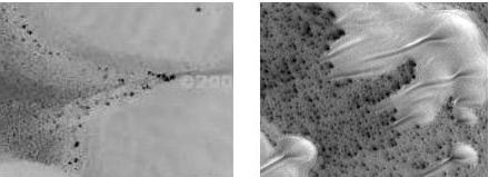
White
Sands, N.M., Google Satellite Image Northern Polar Dunes, Mars, NASA
Image
Shadow
Analysis
The third USGS scientist said the spots on Mars
looked like shadows. Shadows are a very important tool when analysing ground
features/objects in satellite imagery. With shadows you can determine sun
direction and angle, or if sunlight parameters are known from satellite
telemetry, then by simple geometry the length of shadow can be used to determine
the height of ground objects. And in instances where the object itself isn’t
directly visible, the shape of the object can be derived from the shape of the
object’s shadow.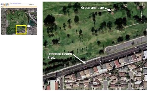
Alondra Golf Course, Redondo
Beach, CA.
At first glance the image above looks like an
airplane view of a golf course from approximately a 45-degree angle. The dark
images are obviously trees, right?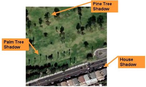
In reality you are seeing a
view from space of tree shadows on a golf course. Shadows of trees,
buildings, and other things can show up extremely dark in satellite images, much
darker than even a black asphalt road or parking lot. While on the other hand,
the green tops of these golf course trees blend in with the green grass and are
less visible or not at all. It the palm tree didn’t cast shadows, we wouldn’t
even know they were there. 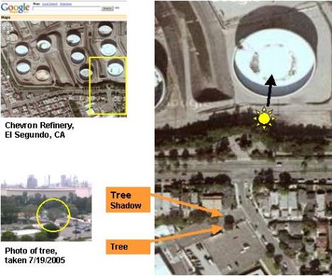
In the above satelitte image of
the El Segundo, CA Chevron refinery, located just few miles from the Alondra
golf course, the shadows off the oil tanks make it very easy to see the
direction of sunlight. And since the tree indicated is in a parking lot, the
crown is visible against the black asphalt (which appears light grey). This is a
clear example of how in satellite images a tree can show up darker than a dark
flat surface, and how the shadow of the tree can be darker still.
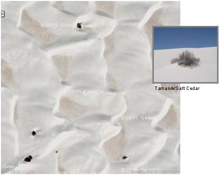
White Sands
National Monument, New Mexico (satellite image from Google maps)
The four black spots in this
otherwise pure white expanse of dunes at White Sands National Monument may not
look like trees or bushes to an untrained eye, but the park service at White
Sands confirmed that the spots are Salt Cedars. The photo insert is of an actual
Tamarisk/Salt Cedar growing at White Sands National Monument and was provided by
the Resource Program Manager.
Resource Program
Manager, White Sands National Monument:
“ The vegetation seen
in the satellite photos are tamarisk/salt cedar trees or bushes. Salt Cedar is
an invasive species here at the park. The yellow circles on the attached aerial
photo clip are in the vicinity of cedar plant...”
Having a confirmed
satellite image of trees growing around white dunes allows comparative analysis
with Mars MGS images. The northern polar dune fields on Mars have thousands of
similar dark spots at the base of white, frost-covered dunes.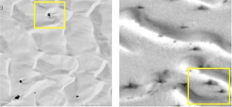
MGS Image
SP2-50805 (above right) is one of many such images of Mars with dark spots
around dunes. 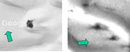
Zooming in
on the Salt Cedar tree in the Google satellite image (above, left) and the spots
in the MGS image SP2-50805 (right), we can see the similarities: both line up
with the sun; both have a dark core with a lighter shadow; and both have shadows
that are distorted by the dunes.
Four Important Characteristics About Shadows:
1. Shadows line up with the direction of sunlight.
2. Shadows
are distorted by ground features.
3. Shadows fall away from the light
source.
4. Shadows can show up darker than the object causing it.
To demonstrate these aspects of shadows, a
3-D computer model was created. 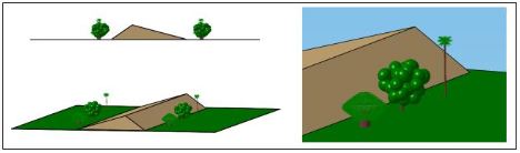
A 3-D model of a palm tree, a thick
round-crown tree (similar in size and shape to the tree in the Chevron Refinery
images), and a thin, hollow diamond-crown tree were placed on either side of a
simple dune shape. The diamond tree is a best estimate, based on prior analysis,
of at least one kind of martian tree (SEE links above, or Google: ringsonmars,
or moundsonmars).
Using the studio modelling
package, light angles were input and the computer program rendered the resulting
shadows (see below). 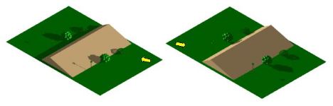
The isometric views of the model
(shown above) are identical except for the direction of light, as indicated by
the yellow arrows, and the resulting shadows. Corresponding overhead views are
shown below.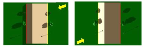
In the
overhead views, yellow lines have been added on the sunny side of the dunes, and
red lines have been added to the shady side. This was done to help visualize how
an object’s shadow falls onto the sunny-side of an object, and away from the
shady-side. It is easy to find examples of this in earth satellite
images.
When vegetation grows along a road, dune, or other identifiable
feature, the vegetation shadows will either fall on the feature or away from it,
depending on the direction of sunlight.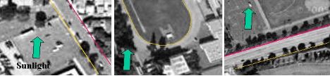
In the three images
above, YELLOW and RED lines have been added to highlight the features (two roads
and a football field). GREEN arrows indicate direction of sunlight. As can be
seen, in each image the trees growing along the yellow line fall onto the road
or field, while trees growing along the red line cast shadows away from the
features.
The same is true of the spots found around northern polar dunes
on Mars.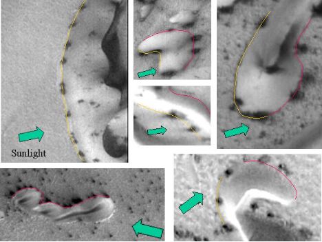
The shadows are
elongated in the direction of sunlight (green arrows) and shadows originating on
YELLOW lines fall onto the dunes, while shadows on the RED lines fall way from
the dunes.
Shape of Shadows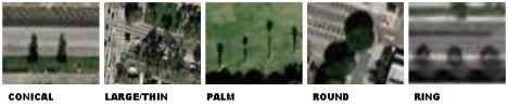
Although it is
not possible to identify the exact species of tree by its shadow, five general
shapes can be spotted in satellite images and species can be grouped by these
shapes. Conical (pine, spruce), Large/Thin (eucalyptus), Palm (various palms),
Round (oak, maple, ficus), and Ring (ficus).
The ring shape is the most
unusual and somewhat difficult to find, but a 1/2 hour search of satellite
images on Google Maps turned up a dozen ring-shadow images (shown below) in the
Los Angeles and Palm Springs area.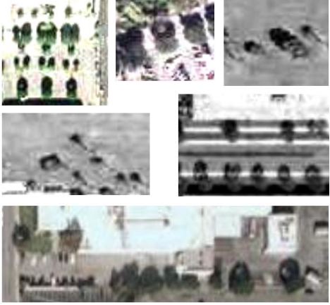
Clockwise: 1) Del Amo Mall, Torrance. 2) El Camino college 3) Palm
Springs 4) , El Segundo 5) El Segundo 6) Palm Springs
The significance of these ring shadows is that they
are frequently found around the northern dunes on Mars. Below are just a few of
the hundreds discovered in Mars Global Surveyor images.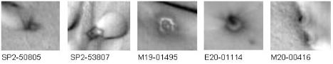
For the Los Angeles area ring
shadows, it was determined by ground observation that in each instance the type
of tree creating the rings is a ficus. In southern California these trees grow
fast and dense, the crown becoming hollow as the tree ages. To prevent the trees
from becoming too large and causing extensive root damage, they need to be
trimmed back periodically. A very thin/sparse hollow shell canopy will create a
ring shadow because the sunlight passing through the shortest foliage path (B)
will create a lighter shadow than the light that passes through the longest path
(A). Voila, a ring shadow.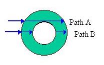
This periodic cut-back
creates the thin/sparse hollow shell canopy that causes the ring shadows
evidenced in the satellite images. This temporary man-made condition lasts only
a couple months until new growth fills in, and thus explains why the ring
shadows are not that common. 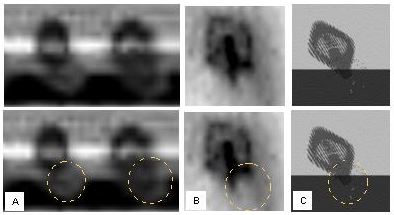
A) Ficus Tree
ring-shadows B) Mars tree ring-shadow C) 3-D Computer Model
ring-shadow
A close-up of Earth and Mars satellite
images, and the computer rendered ring-shadow shows the similarity between the
three . The tree trunk is visible in the right-hand ficus ring-shadow in
Image-A, and is very prominant in Mars image and in the shadow created by the
computer model.
A yellow circle has been added to the lower set of
images to highlight the tree causing the shadow. In Image-A the tree is a
lighter grey against the darker shadow created by a nearby building. In Image-B
there is a curved dark line that may be a mound or heavy roots at the base of
the tree. In Image-C a scattering of spots is all that is visible of the
modelled tree.
On Mars the ring shadows are much
more common, indicating that a thin, hollow crown is a standard tree structure.
The evolutionary cause
for this thin hollow canopy structure is due to the thin atmosphere and low
temperature of Mars. Foliage must receive direct sunlight to maintain
above-freezing temperature. The thin atmosphere of Mars does not conduct/convect
warmth well, and it also does not create much diffuse light by scattering
sunlight in the upper atmosphere. Therefore any leaf in the shadow of another
leaf and not receiving direct sunlight will grow cold and freeze. A tree with a
thin/sparse hollow canopy would allow direct sunlight to penetrate to every leaf
in the tree, which in the 24-hour day of the northern polar summer on Mars,
would allow the foliage to maintain constant warmth for months.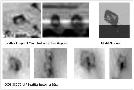
SUMMARY
Although
conditions are harsh in the northern polar regions of Mars, all the elements
necessary for life are present: water (as ice), carbon dioxide in the
atmosphere, temperatures above freezing, and sunshine. Satellite images of White
Sands, New Mexico look strikingly similar to satellite images of Mars northern
polar dune fields.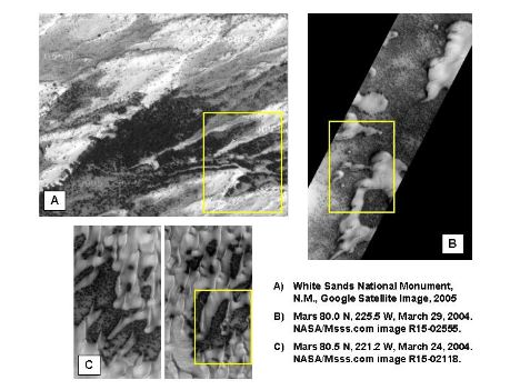
On Mars, as on Earth, wind
blown snow or ice particles collect on the windward side of dunes whenever wind
blows consistantly from one direction. This concentrates moisture along the
windward face. 
White
Sands, New Mexico Northern Polar Dune, Mars.
In a desert environment, this additional water benefits
plant growth. Note the increase in plant life (curved line of dark spots)
growing on the lfeft side of the dune in the satellite image from White Sands,
New Mexico, while the right side of the dune is free of spots/plantlife. The
same is true of many northern polar dunes on Mars.
 |
 |
 |